
Name: Matt Koket
Storm chasing name: StormchaserMatt
What influenced you to start storm chasing?
Koket: I’ve been obsessed with severe weather and tornadoes since I was little. I remember a big storm with a tornado that went through the town I grew up in when I was about 5 years old. I started off being very afraid of big storms but that evolved and grew into curiosity and obsession with the atmosphere and what mother nature is capable of.
How many storm chases have you been on and what’s your favourite to date?
Koket: The short answer is way too many to count. I’ve seen 77 tornadoes over the last 7 years! My favourite chases have to be 9/05/2016 and 21/05/2016, the former was a big dryline day in south-central Oklahoma (OK) where I witnessed 4 tornadoes in a 2 hour period including the EF4 Katie-Wynnewood, OK tornado featured on the Netflix series “Tiger King” and the mile-wide Sulphur, OK wedge tornado.
During a chase, what excites you the most?
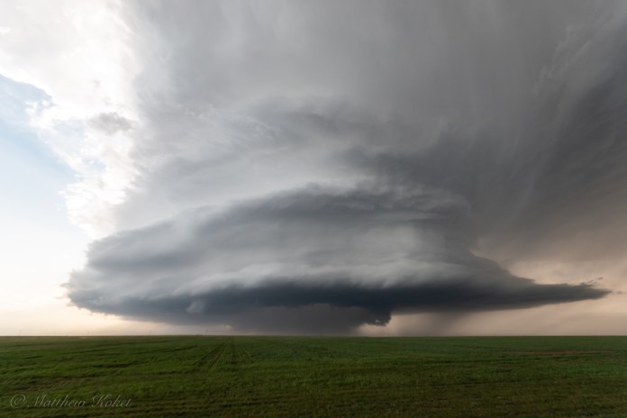
Koket: The thrill of seeing the atmosphere in action! It’s not always about the tornadoes, I’ve been on many chases where the storm structure itself far outshone any tornadoes that may or may not have occurred under them. Getting close to powerful tornadoes is quite the adrenaline rush as well though there are varying opinions on that across the chasing community. I’m also a sucker for a good hail storm! I regularly drive into the most intense part of the storm to really see what it’s capable of.
What is the most dangerous thing you’ve had to deal with whilst chasing?
Koket: I’ve been quite close to several tornadoes, a few scary close calls but I’m still standing haha! The real dangers though are usually other drivers not paying attention to the road and driving in blinding rain occasionally and having to focus on not hydroplaning and crashing.

– LET’S DISCUSS CHASING IN DETAIL –
When do you start planning for a chase?
Koket: Usually about a week out models are in decent enough agreement to outline at least a risk for severe weather, this is when I usually make plans to be off work. As you get closer to the event it becomes more clear where the target areas will be and the potential risks involved with the weather for those days.
What steps do you take to plan out where your severe weather (tornado) target will be?
Koket: Leading up to an event I outline a rough target area based on several factors. The National Weather Service Storm Prediction Center (NWS SPC) outlines its own risk areas which is a good start. From there I check computer models for areas with the most breakable cap, and a good combination of Convective Available Potential Energy (CAPE), shear, and moisture to narrow it down. Day of the chase it becomes more clear with a combination of Convection Allowing Models (CAM) and surface observations along with religiously watching satellites to see where storms are developing to pick a target area.
What do you take when you go chasing?
Koket: Usually I just take my phone and tablet for radar and view observations. I also take my camera of course!
What equipment do you use to chase?
Koket: Again I usually just chase off my phone, RadarScope is extremely useful and the main tool I use while chasing.
If someone wants to start chasing, what should they learn or do and what should they expect?
Koket: The NWS offers Skywarn spotter classes which are a great start to learning safe storm observation techniques! Also, reach out to people on social media, I know several chasers who are more than willing to take first-timers out and show them the ropes as long as they’re willing to contribute some gas money!
Stay tuned to Discover Tornadoes for more tornado news, information, and more. Stay tuned for more storm chaser interviews.
If you’re a storm chaser and would love to be interviewed! Email us at discovertornadoes@gmail.com.


 talks about storm chasing and more...)
[…] RELATED: Storm Chaser Interview: Matt Koket – StormchaserMatt […]